Home | Main Menu | Castle Index | Historical Essays | Recommended Castles | What's New | Links
Travelogue Wales 2006 
Adventures in Castle Hunting
by Jeffrey L. Thomas

      |
Home | Main Menu | Castle Index | Historical Essays | Recommended Castles | What's New | Links
by Jeffrey L. Thomas
| |
Wales 2006: Exploring castles and other ancient sites found in North Wales, followed by genealogy research trips to Brynmawr, and Shipham, Somerset.
Follow this link for a text-only version of this essay (pdf file)
Places Visited:
Rhuddlan Castle → Twthill Castle → Denbigh Castle → Glyndyfrdwy → Valle Crucis Abbey → Eliseg's Pillar → Maen Achwyfan Cross
Basingwerk Abbey → St Winefred’s Well → Ewloe Castle → Snowdonia (Miner's Track) → Beaumaris Castle → St Mary's, Beaumaris
Tomen Y Mur → Conwy Castle → Sycharth Castle → Llangollen → Y Foelas Castle → Part II: South Wales → Brynmawr → Raglan Castle
Tintern Abbey → Crickhowell Castle → Chepstow Castle → Part III: England → Shipham → Cheddar → Tintagel → Wells Cathedral
Priddy Mineries Reverve
Part I: North Wales
For our two week holiday to Wales in 2006, we chose three different accommodations. The first was a 7-night time share exchange near the town of Dyserth in northeast Wales, followed by four nights near Brynmawr in south Wales, and finally 4 nights near Shipham in Somerset, England. The first week in north Wales was strictly recreational, while the second week was primarily about gathering information regarding my Hares ancestors.
After a terrible flight from Baltimore to London, Heathrow, and a longer than normal delay in landing, arriving at the terminal, and getting through customs, we finally found ourselves in our rental car headed for Wales. The plan was to head up the M5 north to Birmingham, then pick up the M6 north before heading west into Wales. This route worked out well, and, although for most of the journey the traffic was quite tolerable, not being able to get any sleep on the plane meant that after a couple of hours driving I was dangerously close to falling asleep behind the wheel. We decided to pull off on one of those services exits conveniently placed about every 25 miles or so, to take a break and drink some coffee in hopes or reviving. I consumed three 16-oz cups of coffee in about half an hour, and that seemed to do the trick. We left the rest area refreshed and ready for the final leg of the journey.
Although we had planned to visit an historic site on the way to our accommodations, the trip took longer than planned, and therefore we did not arrive at our destination until mid afternoon. We arrived at our time share exchange, Graig Park, at about 3:30 and had no problems checking in. We had exchanged for a studio unit, that, while small in some respects, still featured a full kitchen, dining room and living room with sofa. The bedroom and bathroom were a different story; both were small and cramped, but we managed just fine.
After unpacking we decided to venture out and visit nearby Rhuddlan Castle, less than two miles down the road. Unfortunately we arrived at the castle at 4:30 after the last admission of the day. Still, I was able to take some photos from the car park, and some nice distance photos of the castle from across the bridge below the town. Given the long day, we decided to pack it in for the evening. We stopped by a local Spar (grocery store) on the way back to the room.
Our first accommodation on our 2009 holiday to Wales was a 7-night time share exchange at Graig Park, near the town of Dyserth in northeast Wales. This was a large holiday resort with different size cottages spread out over the grounds. Most of the cottages were Scandinavian style. Although I'm sure there were some nice, large units there, we were only able to exchange for a small one-bedroom unit that was a little worn and definitely in need of an upgrade. On the other hand, we were close to the the A55 expressway which provides easy to access to most of north Wales. During the week we were entertained daily by two pairs of peacocks, the noisiest of which (a male) we dubbed “Fred.” Amusing at first, by the end of the week we grew a bit tired of the loud screaming that continued well after dark and resumed about 4:30 the next morning. Still, we enjoyed Fred and his friends, even giving in twice and feeding him bread outside our door. It was, after all, their home.Rhuddlan & Twthill Castles
The next morning was Sunday, and, although the weather was warm and free of rain, the skies were overcast. After preparing breakfast, we decided to return to Rhuddlan, to visit both the Edwardian castle, but also locate and photograph the earlier motte castle nearby which played a significant role in the conquest of north Wales in the late 11th century. Although we had visited Rhuddlan many years ago, on that day the castle was closed. Even though the castle gates were locked, it was easy to climb over the low castle walls, which was exactly what we did. However, doing so limited our time there and resulted in less than satisfactory photographs of the fortress. This time we took our time and explored every aspect of this impressive castle, known for the façade of it’s double tower gatehouse, which was eventually robbed of it’s facing stone on the lower third of the towers after the castle fell into disrepair.
Although Rhuddlan retains some impressive features, the real reason I was there was to visit and photograph the aforementioned motte castle (old Rhuddlan), known today as Twthill. Having spotted the motte from the A-road below the site on the previous day, I thought that the best approach might be from the river side. I soon regretted this decision as I became bogged down in the swamp-like terrain that passes for the banks of the river. I continued on and struggled up the adjacent hill, while Parthene returned to the castle (a smart move). Although via this route I did manage to get close to Twthill, a man walking his dog informed me that there was a public footpath to the site leading from the road behind the castle.
As is often the case, although I had seen photographs of the motte at Twthill, I was unprepared for both the size and height of the motte we encountered. It is easy to see while first the Saxons, then later the Normans constructed fortifications here. The motte rests on top of a large spur overlooking the river on one side and commanding a wide view of the land to the south. On this side of the castle the drop to the river would have provided a natural defense, while the other side of the castle would have been defended by a walled bailey surrounded by a ditch.
By the time we finished with the castle it was lunch time, so we decided to head to the town and castle at Conwy along the coast where I had read the George and Dragon pub served a good lunch and good ale. We decided to approach the A55 to Conwy via the A road leading through Rhyl, a popular seaside resort. This was one of the few logistical mistakes of the trip. Not only was the countryside unattractive (think tacky beach community), but we had forgotten that it was a Bank Holiday weekend in Britain, so the coastal resorts were choked with tourists. It took us a long time to reach the A55, although we still arrived in Conwy in time for lunch. We eventually found the George and Dragon, and they and the entire town were very busy on this Sunday afternoon. In fact, we were told that if we ordered food it would likely be a good 45 minutes to get it. Since we were in no hurry this wasn’t a problem, and the extra time gave me the opportunity to have two pints of real ale from the hand pump, Greene and King IPA and Old Speckled Hen, both of which were very good. While waiting for your food we chatted with a young couple at the next table. He was from Liverpool and was soon telling us about all the great things to do and see in this former home of the Beatles.
Our food finally arrived and we enjoyed out two jacket potatoes with cheese and ham. Afterwards we decided to explore Conwy’s town walls, saving the castle itself for a later day. The town walls at Conwy are nearly complete, and offer visitors an interesting perspective on the town’s defenses. The high curtain wall that surrounds and connects to the castle is punctuated by it’s own series of defensible towers, most of which survive relatively intact. The tower most distant from the castle affords a good photo opportunity for castle buffs, as does the “Quay” section of the wall near the river.
After finishing our tour of the walls, we returned to the town to browse through some of the shops there, however the crowds drawn here by the long weekend made the experience less than enjoyable, so we left, determined to return on a less crowded day. Rather than return to Dyserth via the A55, we decided instead to take the B-road south through the beautiful Vale of Conwy, eventually returning to Graig Park via Denbigh. We had dinner that night in a local pub where Parthene enjoyed roast lamb.
Denbigh Castle
Often overlooked Denbigh Castle provided yet another opportunity to document a Welsh castle with my digital camera. Although Welsh in origin, the ruins at Denbigh are of the later castle constructed during the Edwardian castle building period of the late 12th and early 13th centuries. Although Denbigh is less famous than its cousin castles at Conwy, Caernarfon and Beaumaris, the castle is remarkable because only here and at Conwy, can the visitor explore substantial sections of surviving town wall. In other words, like Conwy, the castle experience at Denbigh includes the castle itself along with the fortified town wall.
We arrived at the castle shortly after it opened, and were pleased to learn that the castle is now protected by an attendant working at the visitor’s center just inside the main gate. One of the castle’s remarkable features is the great triple-tower gatehouse, which, although today greatly ruined, remains an impressive and unique feature among the great Edwardian castles. Standing guard over the gatehouse is a time-worn statue, supposedly of Edward himself, the features of the statue long eroded away. We paid our admission and soon found ourselves exploring the large outer ward, which like most castles is devoid of its wooden buildings, but nevertheless offers outstanding views of the beautiful countryside surrounding the castle. Two areas of note along the curtain wall are the complex postern gate leading down to the town wall, and the “Green Chambers,” with it’s surviving finely carved corbels of a lion, bat and braided haired woman.
After exploring the castle a bit more, it was time to return to the gatehouse and request the key to access the town walls. While at Conwy, the towers along the town wall are for the most part similar and uniform, at Denbigh the towers are unique and more complex, the Goblin Tower acting almost as its own stand-alone fortification. Although far less of the town wall survives at Denbigh, it provides an interesting educational counterpoint the walls found at Conwy. One thing the walls share in common with Conwy, are the beautiful vistas of the north Wales countryside. We spent most of our time here exploring the Goblin Tower with its long flights of stairs leading all the way down to the town, before returning to the castle and departing.
By this time is was time for lunch, so we decided to head for the nearby market town of Ruthin, known for its castle and medieval banquet. Unfortunately it was a “Bank Holiday” Monday, which meant that all retail shops and even most of the pubs were closed. Fortunately, the Castle Hotel in the middle of town was open and this is where we had lunch. Good ale – bad food, with the fish ‘n chips barely edible. After lunch we still had plenty of the day left, so we spent the rest of the afternoon driving along the A5 west of Corwen, and on the smaller B-roads, one of which lead back to Denbigh and eventually to Graig Park in Dyserth.Glyndyfrdwy, Valle Crucis Abbey & Eliseg's Pillar
We decided to spend the following day exploring one of our favorite places in Wales; The Dee Valley, Llangollen, and the beautiful and historic sites nearby. We began by visiting Glyndyfrdwy, also known as aka Owain Glyn Dwr's Mount, an important site from Welsh medieval history. What appears to be a modest motte-and-bailey castle just off the A5 between Llangollen and Corwen, was once the manor home of Welsh patriot Owain Glyn Dwr. Glyn Dwr, with a lineage connecting back to some of the medieval rulers of Wales, rose in revolt against oppressive English rule in the early 15th century, although, the trigger for his revolt was a land dispute with his powerful neighbor, Reginald de Grey, Lord of Ruthin. The site was destroyed by English forces in 1403. From the Cadw plaque at the site we learn the following:
"Near this spot at his manor of Glyndyfrdwy, Owain Glyn Dwr proclaimed himself Prince of Wales on 16th Sept 1400, so beginning his 14 yr rebellion against English rule. This mount, known locally at Owain Glyndwrs Mount, is actually the remains of a 12th century castle motte built to command the route through the Dee Valley. Like the motte nearby at Sycharth, it may have continued in use until the late 14th Century but Owain's manor is likely to have been in the square moated area across the field. This would have been defended by a water filled moat, palisade and gate."
There is a small parking area across the road from the castle. We carefully crossed the A5 and made our way to the site. The motte is tree-clad, steep, and still impressive. We climbed to the summit of the motte and were rewarded with impressive views of the valley and river below. From our vantage point we could also appreciate the large, flat, moated area mentioned above. The combination of castle, moat, pallisade and gate, was an impressive estate in its time. We really enjoyed explore this, a must-see stop for anyone following the Glyn Dwr trail.
Our next stop was beautiful Valle Crucis Abbey, set in stunning countryside. Valle Crucis is a Cistercian abbey located in Llantysilio not too far from Llangollen. The abbey was built in 1201 by Madog ap Gruffydd Maelor, Prince of Powys Fadog. Although the ruins of the abbey are not nearly as impressive as those found at Tintern, the countryside is more picturesque, and the abbey also holds a unique surprise for visitors. We parked the the modest car park close to the entrance and paid our admission to the site. The first thing that struck me about the abbey was the beautiful west front with its rose window tracery still intact. The nave is large, with green grass, and the stumps of large pillars that once carried the weight of the roof, all now framed by the hills beyond.
The most impressive survival here is the vaulted chapter house, a nearly-complete building with two floors. The chapter house holds a very fine collection of medieval memorial sculpture preserved in the upstairs (the surprise) primarily from the late 13th century. Some of these are magnificent, including the slab for Madog ap Gruffudd. His inscription reads "Here lies Madog son of Gruffudd called Fychan." Madog ap Gruffudd (d.1306) was the great-grandson of the founder of the abbey, and great-grandfather of Owain Glyndwr.
The site is also home to the only remaining monastic fishpond in Wales (yet another surprise). A bench located on the far side of the pond provides outstanding views of the rear of the abbey. We remained here for quite a while. I find that the history and beauty of Valle Crucis makes it one of those places that are difficult to leave. But, we had another interesting site to visit right next to the abbey, and with it we departed medieval Wales and entered the Anglo-Saxon world and the Welsh kingdom of Powys.
Found immediately next to the abbey is the 9th-century Eliseg's Pillar. According to the Cadw guidebook for Valle Crucis Abbey:
"Eliseg's Pillar is the remaining portion of a tall round-shafted cross of Mercian type, which gave its name to the valley and the neighboring abbey. All that survives today is part of the rounded lower shaft, on one side of which it is just possible to see weathered traces of early lettering. The roll mouldings at the top of the surviving section mark the point at which the squared and tapering upper portion of the cross would have originated; this may have continued to a height similar to that of the rounded shaft before being surmounted by a cross-head. The monument was probably erected in the early 9th century, celebrating the exploits of a king up to a century earlier. Eliseg's campaigns may have provoked the construction of Offa's Dyke by the English, as a defence against the Welsh, in the mid 8th century. "
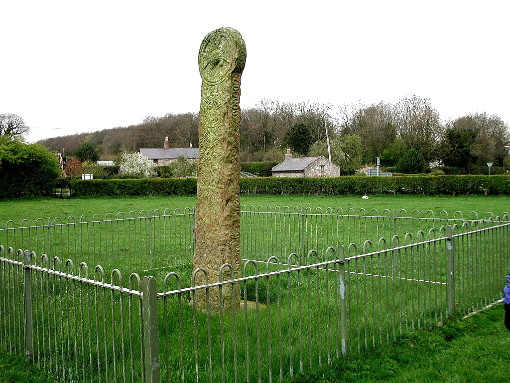
Although the pillar isn't as impressive as the carved crosses found at Nevern, Carew, and the soon-to-be visited, Maen Achwyfan, it pre-dates these fine monuments by a couple of centuries. It is one of the few surviving monuments in Wales that can be traced back to the turbulent 9th-century in Anglo-Saxon Britain; Powys, Mercia, and the great King Offa. For me, that alone makes Eliseg's Pillar unique and well worth visiting.
The next day was overcast, and after breakfast we headed north east. Our primary goal for the day was Ewloe Castle for a picnic lunch, however we had time to make several other stops before arriving there. Our first stop of the morning was at the beautifully carved cross of Maen Achwyfan near Flint. The cross stands alone in a farmer’s field, dates from about the year 1,000 AD, and is comparable to other carved crosses in Wales. The cross is whole and complete and contains carvings on all four sides, the most famous of which depicts a man trampling a snake.
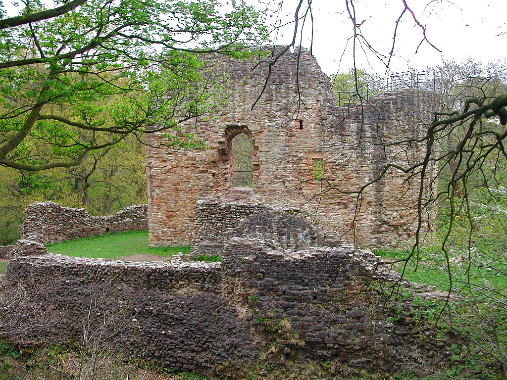
Our next stop was at the ruined abbey in nearby Basingwerk. Parthene and I had visited the abbey years ago, and we both had few memories of the visit. Parthene remembered the parking lot next to the pond, and I remembered the handsome double arches surviving in the abbey church. We arrived at the site at about the same time as a bus load of school children, however their destination was another part of the park and not the abbey itself, which lies within the park. There is no charge to visit either the park or the abbey. I was a bit surprised because the ruins were more extensive than I remembered. Parts of the nave and cloister survive as do several associated and domestic buildings, the surviving stonework still exhibiting a pleasing honey colored to reddish hue. There was some trash at the site, including a discarded 12-pack of beer and evidence of impromptu fires in a couple of corners of the abbey, which you pretty much have to expect at sites that have basically unrestricted public access. Still, Basingwerk is definitely worth a visit and we were glad we made the time to do so. Afterwards I thought that we might be able to find the location of the early Norman motte castle in the area, however these efforts proved fruitless, despite the best efforts of the woman at the visitor’s center.
Just up the road is the church at Holywell, famous for its association with St. Winefred’s Well, one of the many holy wells found throughout Wales and Britain. Like Basingwerk, we had visited this site before, although, again, we had little memory of that earlier visit. My main reason for returning was to get some digital photos of the site to supplement the web page I have for the well.
By the time we finished here it was time to think about lunch and Ewloe Castle, so we made a quick stop in a nearby village, finally locating a café making sandwiches for lunch. We found the upper read-side car park for Ewloe with little difficulty, and were soon hiking across the field to the woods and the castle. While there we spent some time chatting with a friendly woman who was visiting the castle for the first time in order to write a story about it for her local paper. I told her to be sure to mention the distinctive D-shaped tower, a common feature of native Welsh castles.
Ewloe has become a more popular attraction since our first visit some 10 years ago. Although the castle is sign posted at the car park, a historical marker now marks the entrance to the castle through the woods, and the path through the field to the woods is now well worn. Upon seeing the castle again I was a bit alarmed because of the marked changed in the color of the stone. In 1995 most of the surviving masonry was of a pleasant honey to red color, similar to what we found at Basingwerk Abbey, however now much of the stone has been overtaken by black mold, robbing the castle of most of its warm glow. Nevertheless, Ewloe is still a fascinating site set in a beautiful wooded location. We explored the castle, took some photographs and then enjoyed our picnic lunch in the castle’s upper ward near the D-tower. Afterwards I explored around the base of the castle and the makeup of the curtain wall. Since Welsh castle builder commanded fewer resources, it is often said that their stonework was of a poorer quality than their Norman counterparts, and you can see evidence of this in the base of the curtain walls at Ewloe.
Afterwards we returned to the car and then decided to find the new visitor center for the park located on the opposite side we came in on. We managed to do so, and, although the center provides certain information on the park and the castle, we found little that interested us here.
Snowdonia
I was determined to save a sunny day for a hike in the Snowdonia Mountains of northwest Wales. Having visited this region of Wales on several previous trips, we were anxious to return to explore this beautiful part of Wales. I decided that a good half-day hike would be appropriate, and thought that doing the “Miner’s Track” to the lakes and back would fit the bill. On the way to our trail for the day we stopped at the town of Betws y Coed for petrol (and a bathroom), and were reminded of the beauty of this well-known tourist destination. After departing is was not long before we arrived at the Pen y Pass car park which serves as the starting point for both the Miner’s Track and the Pyg Track up Snowdonia. Although we did manage to select a sunny day, the high peaks of Snowdonia were shrouded in mist as we started, and a persistent strong wind made conditions less than ideal for enjoying a picnic. Nevertheless, we started down the track and were soon enjoying the outstanding scenery this part of Wales is famous for. Along the way we encountered some grazing sheep, and were surprised when we came across a family of mountain goats, nimbly working their way through the rocks in search of grass.
We hiked about 2 miles in, passing over the lake via the Miner’s causeway and pausing at the ruined miners housing to find a place for our picnic. We found a nice spot just beyond the ruins overlooking the lake, and by turning our backs to the wind, were able to enjoy our picnic in relative comfort. We were joined by two hungry seagulls and a solitary sheep that seemed determined to chase the gulls off his grazing spot. Had it been a calmer day, we probably would have lingered longer here, but the strong winds continued, so we decided to hike back to the car after our picnic. Having finished sooner than expected, we decided that there was still plenty of time to visit another of our favorite places in Wales, the lovely town and impressive castle of Beaumaris on the Isle of Anglesey.Beaumaris Castle
Beaumaris is one of the premier beauty spots in Wales. Even without the castle the view of the surrounding countryside across the Menai Straits and beyond to Snowdonia is one of the most beautiful in all of Wales. It was a beautiful, sunny, blue sky day when we visited, although the strong winds near the water were of some concern as we parked the car and headed towards the castle. Like Conwy, we had been to Beaumaris several times over the years, however here the town and castle are quite different, both less crowded and more tranquil than Conwy. Because of this added charm, Beaumaris is always a pleasure to visit. As we made our way to the castle, we immediately noticed that part of the beautiful moat that surrounds the castle was closed due to construction. We later learned that this was due to a new visitor’s center being built for the castle. Even with this intrusion, most of the lovely façade of the castle remains unspoiled. We approached the gatehouse with excitement, this, like several other of our castle re-visits, representing my first opportunity to photograph the castle with my digital camera.
The first part of our visit was uneventful with no surprises, but that soon changed, once I noticed what appeared to be shiny new railings on a section of the castle wall walk. Parthene and I had been visiting the castle since 1994, and during all our previous visits, the wall walks atop the castle had been closed to the public, denying visitors the opportunity to explore this little-know feature of the castle. Having been disappointed on all previous occasions, I had no reason to believe that this visit would be any different, however my pulse quickened when I spotted the new railing. As it turns out, the wall walks were open (had just been recently opened), so Parthene and I climbed one of the towers in anticipation of a new experience. As I had always suspected, the views from the wall walk atop Beaumaris are even more spectacular than those perspectives gained from other areas of the castle. Although little more than a quarter of the walk has been reopened, it is enough to provide better, more complete views of the castle itself, as well as even more spectacular views of the Menai Straits and the mountains of Snowdonia.
What I had not expected to encounter was all the interesting detail found here, including spiral stairs in the towers along the wall, and other living accommodations, including latrine chutes. Unlike other wall walks, which are basically walk ways between main towers, there are accommodations with accompanying features along the walks between the towers, the likes of which I had never seen and therefore found difficult to interpret. As far as my experience is concerned, there is nothing else like it in Wales, and I hope one day the guidebook is revised to mention some of these features. While I would agree with commentators who claim that that the wall walk at Harlech is one of the best castle experiences in Wales, having now experienced the wall walk at Beaumaris, I would have to say that Harlech has been surpassed.
This new discovery was certainly one of the highlights of the trip. After spending a bit longer at the castle, exploring the inner passageways and Chapel Tower, we left the castle and decided to enjoy a drink at the “Ye Olde Bull’s Head” pub/hotel, where we had stayed a few years earlier. Here the ale was good, and we enjoyed talking and joking with a group of locals having a pint after work. Upon departure we asked for directions to St. Mary’s church in order to revisit and photograph the elaborately-carved coffin lid of Joan, daughter of King John and wife of Llywelyn the Great. By this time it was late afternoon and time to start the long journey home. We left Beaumaris the same way we always have – looking forward to returning here again.
Tomen y Mur
Our main target for the day was the motte castle of Tomen y Mur, located a bit south of Dolwyddelan Castle in Snowdonia. This is a lesser known site that I’ve been interested in because the medieval motte castle is located within the boundaries of a Roman fort. The site rests on a hill in the middle of a field close to the intersection of the A470 and A487. Although we had directions to the site from our Cadw guidebook, because we didn’t have an OS map for the area, it took us longer than expected to find the small track road leading to the site. Fortunately the site is recognizable by a sign and small car park located directly across from the motte, where we parked our car in anticipation of visiting this interesting multi-use site.
We were fortunate because our guidebook contained a small map of the site, otherwise we would have missed most of the Roman features. Although the history of the site likely begins before the Roman occupation, no traces of this early history remain. What survives today is a well-defined Roman fort, a possible Roman road, and a small amphitheater, which one would not be able to detect without the help of a guidebook or OS map. After the Romans abandoned this far-flung outpost, it is said that the site was reoccupied by the Welsh for a period of time. Later in the 12th century, the Normans built a large motte castle here within the walls of the Roman fort, and it is the remains of this still-impressive motte that dominate the site today. We approached the castle via a public footpath at the car park, walking along a cobbled road that some historians believe is the site’s original road leading from the fort to the amphitheater. Today the amphitheater is little more than a series of round grass-covered walls down to the foundations located near the car park. Recognition of the site is hindered by the low walls and a stone fence surrounding the field cuts through the top third of the amphitheater. Had it not been for our guidebook we would have missed the site altogether.
The proposed Roman road leads to the site of the Roman fort and later motte castle, past a ruined stone farm house that somehow adds to the atmosphere of the site. Once you get past the farmhouse and on top of the ridge, you can clearly make out the lines and dimensions of the Roman fort, still marked by low stone walls. The motte at Tomen y Mur, although much damaged is still quite large and steep. Unlike other motte castles, the summit of the motte here is hilly rather than flat. Once we ascended the motte, the strategic value of the site became apparent, as both the Roman fort and the castle would have commanded all the surrounding ground with the exception of the modern approach to the site. Although this is a beautiful location well worth visiting, the castle also commands a rather ugly view of a nearby nuclear power plant with many power lines emanating from the main building.
A portion of the rear of the motte has been scrapped away, revealing a small quantity of cut stone. This is likely an indication that parts of the castle were once fortified in stone, however I wondered if the stone was possibly part of the original revetting of the motte. Today, the Roman, Welsh and Norman soldiers have been replaced by grazing sheep, most of whom were a bit wary of our presence. This is a site where we could have lingered much longer, however our visit to this most interesting site was one of three activities scheduled for the day.
Next on the agenda was a visit to lovely Bodnant Gardens on the way back up to Conwy. Many would argue that Bodnant are the premier gardens in Wales, and we would certainly agree. Although we had been there before, Parthene and I were glad to revisit the site, being certain that the gardens would be awash in their glorious spring colors. We were certainly not disappointed in this regard as we spent the next couple of hours walking amid colorful azaleas, rhododendrons, and other spring plants and flowers in full bloom.
Conwy Castle
By the time we finished here it was late afternoon and time to head a few miles up the road to the medieval walled town of Conwy and its “World Heritage” site castle. We have been to Conwy before and had visited the castle earlier in the week on a “Bank Holiday” Sunday, when the town was quite busy. On that day we contented ourselves with having lunch and exploring some of the town walls, saving the castle itself for a later day.
We arrived at the castle about an hour before closing, and once we lost a group of tourists on a bus tour, who remained for only a few minutes, we pretty much had the place to ourselves. Conwy is certainly one of the most complete of the Edwardian castles, and the tall towers here offer some magnificent views of the river and surrounding countryside. Having been to the castle twice before, this was more of a reminder visit, an opportunity to take some digital photographs of the castle, rather than a visit of discovery. We spent about an hour at the castle, exploring the many towers and rooms, ducking into one tower to avoid a quick-moving shower. Afterwards we walked around the town, purchasing sandwiches for dinner at a local bakery, before heading back to the car for the short drive back to Graig Park.
Although it is always nice to revisit places like Bodnant Gardens and Conwy, for me, the real treat of this day was our visit to Tomen y Mur, a beautiful place of historic importance that is sadly overlooked by most people in this part of Wales. Tomen y Mur is one of those wonderful “off the beaten path” sites that are so numerous throughout Wales and Britain.Sycharth Castle
The following day we hopped back on the Glyn Dwr trail and visited Sycharth Castle in the village of Llangedwyn, Powys. While Glyndyfrdwy was part of Glyn Dwr's estates, Sycharth was his castle, his court, and his home. It is therefore east to argue that Sycharth is the more important of the two sites. Like Glyndyfrdwy it was destroyed by English forces during his rebellion. Rather than recounting the castle's history, I will let the late Richard Williams do so instead. Richard was a frequent contributor to the Castles of Wales website, and was passionate about his Welsh heritage, and Welsh history.
"To the casual traveler along the country lane, the nearby farmhouse set in the lee of thickly-wooded escarpment attracts little attention. The building appears no different from many such homesteads in this southeast corner of Clwyd, but a bare kilometre from the English border. Yet, 600 years ago this was the noblest house in all of Wales, and between 1400 and May 1403 it was more. It was the focal point of a people who were enjoying, for one of the few brief instants in history, their existence as a nation. It was the home of Owain Glyndwr, their prince.As the most prominent member of his class, and conceivably one of the more benevolent, Owain Glyndwr made an ideal leader of the rebellion. In May, 1403, Prince Hal, at the age of 16 already showing the martial qualities that he would exhibit later as King Henry V at Agincourt, put both Glyndyfrdwy and Sycharth to the torch. Until its fall, Harlech (shown right) was to become Owain Glyndwr's centre of operations. After he was forced to resort to guerrilla warfare (until some time around 1415) he ephemerally disappeared from the historical stage. "
I found myself approaching the site with a sense of great reverence. It's not easy to find and there are few markers to lead the way or advertise the site, something that always bothered Richard. Sycharth enjoys a commanding position overlooking the valley, its defensive positioning being obvious. We made our way down a track next to a farmer's field and eventually spotted a large motte with a historic marker near its base. Both the motte and site overall are much larger than Glyndyfrdwy. Although the motte is greatly eroded, it is still steep, wide, and protected by a deep surrounding ditch. This was obviously a substantial castle. We climbed to the top of the motte and were able to survey the large bailey beneath the castle and imagine the buildings that would have been present. The summit of the motte also affords visitors wide views over the surrounding countryside. We spent about an hour here, exploring the castle and just sitting and contemplating the momentus events that took place here. As we made I way back to the car I got the feeling that we had visited a cathedral rather than a castle. Silly, right?
"Since 1410 most Welsh people most of the time have abandoned any idea of independence as unthinkable. But since 1410 most Welsh people, at some time or another, if only in some secret corner of the mind, have been "out with Owain and his barefoot scrubs." For the Welsh mind is still haunted by it's lightning-flash vision of a people that was free." Gwyn A. Williams After visiting the castle we had lunch in Llangollen, another one of our favorite places. Previously we spent about a week there at the Royal Hotel in a room overlooking the river. Marvelous. We enjoyed a pub lunch but didn't make the climb to Castell Dinas Bran as we had done on previous trips. The rest of the day was spent doing what I like to do; seeking out lost castles that nobody has ever heard of and are difficult to find. The target this time was little-known Y Foelas Castle near the town of Pentrefoelas. Like most of these lost castles, the only way to find Y Foelas is to use your trusty Ordnance Survey map. The tree-covered motte is barely visible in the deep woods and it is somewhat difficult to climb to the summit. (Of course I did it anyway.) Although there is little known about the site, it appears to have been a typical motte-and-bailey timber castle that was abandoned by the 12th century. Score another lost castle.
Our time in north Wales was over. It had been an amazing trip driving through the historic countryside visiting castles, abbeys, crosses and other interesting sites. Now it was time to shift gears on move onto the next phase of our trip; a visit to my ancestral home of Brynmawr, Wales, and there were still more castles to see!
Part II: Brynmawr, South Wales
We departed Graig Park and headed for Brynmawr. Although most of the journey was pleasant, the trip took longer than expected, and we ran into a significant traffic tie up in the town of Hereford. We finally arrived in Brynmawr around 11:30 noon and parked the car on Alms Street near Market Square. We were hungry so we headed for the Gwestry Bach pub for lunch, however being told the pub didn’t open until noon, we decided to walk around the town. Although I am proud of my ancestral home, both Parthene and I were disappointed at the initial appearance of the town, as there appeared to be even more trash and dirt on the streets than was the case in 2004. We began our walk by heading up Beaufort Street, the town’s main business street, towards King Street in search of the remains of Rehoboth Chapel, the town’s first non-conformist church dating from 1828. In 2004 (to the anger of many of the town’s residents) they had begun to tear down this historic building, a process that had now been completed. Today, the only reminder of the church is the dilapidated and overgrown cemetery at the rear of the property. We were later told that the redevelopment of the site had been halted because of a legal disagreement regarding what to do with the cemetery.
By this time is was noon, so we headed back to the Gwestry Bach for lunch. Unfortunately they had no beer on the hand pump, so I had to settle for a Brains from a CO2 tap. After lunch we decided to look up Sue Ball at the Brynmawr Scene Tourist Shop on Bailey street, but had difficulty finding it. We were finally taken to the shop by a helpful man and his small son, however the shop was closed because the town was preparing for its annual citizens awards ceremony later that evening. We decided instead to explore more of the town, including Orchard street, where I only recently learned my Hares ancestors were living in the 1851 census.
Next it was off to the Brynmawr Cemetery, where (again) I had recently discovered was the final resting place for two of my g.g.g. grandparents, Israel and Mary Ann Hares, and their daughter Mary Ann Haines and her husband James. Locating the grave of Israel and Mary Ann was the primary reason for our return to Brynmawr, and the recently published Brynmawr burial CD had already provided me with the section, row and grave number for Israel and Mary Ann and their daughter Mary Ann. Therefore, we went to the cemetery fairly certain that we would be able to locate the graves in question, and knew that we could rely on the sexton of the cemetery, Steven Brown, who had also helped us in 2004.
Unfortunately, Steve was not at home when we arrived, so we determined to search for the graves on our own, not knowing if either grave contained a marker. We first began to look for section 6 and the grave of Israel Hares, however the ordering of the sections seemed to defy logic and after spending a lot of time searching in vain, we gave up. We decided instead to search for the grave of Mary Ann Haines in row 10, section 3 of the cemetery. Here we had better luck as Parthene was able to identify the row that the grave should have been on. The problem was there was a large tree planted where the Haines grave should have been with no sign of the marker. Not being deterred by this, I pulled back the branches of the tree, and to my surprise, there was the Haines marker, dead in the middle of the tree, the marker pushed at an angle by the growth of the tree trunk. The marker mentioned the dates of birth and death for both James and Mary Ann (Haynes) and was relatively good condition. We photographed the marker (with some difficulty) and recorded the inscription.
By now is was approaching check in time, so we decided to head down the road to our accommodations for the next four nights, Glangrwyney Court Country House Bed and Breakfast near Crickhowell. This is a lovely Georgian manor house surrounded by beautiful gardens, set in the Brecon Beacons with the rolling Black Mountains beyond. The house features four acres of walled gardens and thirty-three acres of parkland. We had booked a four night stay in what I think was their best room, a luxury double room located on the 2nd floor (1st floor). The room featured a comfortable bed, two comfortable chairs, and large window overlooking the front of the house. We also had a large bathroom with a full sized tub and steam shower. Our room overlooked the front of the house where we enjoyed watching sheep grazing on the front lawn. The back of the house had a seating in the gardens and of views of the Black Mountains. The B&B did have a prohibition against eating or snacking in the room, as well as a charge for enjoying an adult beverage that wasn't purchased from the B&B. We didn't exactly follow either rule, but we very much enjoyed this accommodation.
Although we were tired from the long journey from north Wales, it was still too early to retire for the evening, so, after exploring the house and grounds, we decided to head back out to scout the surrounding area. Although there were several pubs in Crickhowell and Abergavenny, we ultimately settled on purchasing wine and food at a local Spar in Abergavenny before heading back to the room for the evening. It had been a long day, and we very much enjoyed our ploughman-like dinner and wine seated in front of our room’s marvelous picture window seated in our comfortable and plush armchairs.
The next day was Sunday and the forecast was for sunny skies, so we decided to make this day our one purely recreational day, putting aside family history for the time being. Having been several years since our last visit, I thought that it would be perfect to take the opportunity to visit marvelous Raglan Castle and Tintern Abbey to snap some digital photos. After enjoying breakfast in our B&B we headed down the road to Raglan, arriving just as the castle opened at 10 AM. Raglan is one of Britain’s finest ruined castles, as it retains an impressive amount of fine detail in what was once one of Britain’s showplace Tudor-ear castles. After paying our admission, we paused outside the great gatehouse at Raglan to take photographs of the gargoyles perched at the corners of Raglan’s two octagonal main towers. This required the camera telephoto lens and tripod, both of which were used to great effect to record most of the whimsical gargoyles. Next it was inside the gate and onto the pitched stone court to examine the back of the gatehouse and the range of buildings contained in the court. As we worked our way through the castle, we finally arrived at Raglan’s great hall with heraldic shield, and finally the once glamorous Fountain Court, containing the castle’s Grand Staircase, ruined but still majestic.
Raglan CastleWe then exited through the south gate to take in views of Raglan’s moat the great tower, both of which lie outside the castle. Some of the better views of Raglan’s surviving detail can be viewed from the bridge leading to the Great Tower and from the summit of the tower itself. On the bridge we were able to again use the telephoto lens to capture some incredibly close detail of the heraldic shields on the adjacent tower, and equally fine detail of the top of the castle from the tower itself. To me, this part of the castle is the highlight of any trip to Raglan. Afterwards we spent some additional time exploring the many rooms and towers available to visitors, briefly stopping by the exhibition housed in the gatehouse tower before departing the castle. Raglan, like Beaumaris, is a castle that never disappoints, and we felt fortunate that we had the opportunity to visit this magnificent castle on such a beautiful day.
We decided to get to our next destination, Tintern Abbey, via the scenic B-road from Monmouth, approaching the site from the north. As was the case with Raglan Castle, it had been many years since we had visited the abbey, and as soon as we pulled into the lane leading to the abbey, we could see that the site has been transformed in recent years. In short, this destination is now more popular than it once was, one indication being the double car parks next to the abbey, both of which were already filled to capacity upon our arrival. Of course this was a Bank Holiday Sunday, which likely accounted for most of the throngs of visitors we encountered. Most of these were not bothering to visit the abbey, but rather to hike the Wye River path that runs next to the abbey along the river, or just enjoy a scenic picnic spot for lunch. We had to drove around for about 15 minutes but were finally able to get a parking place in the car park closest to the abbey.Tintern Abbey
We paid our admission and headed for this majestic ruin, easily the most complete and impressive ruined abbey in all of Wales. I have always been enchanted by the wide open spaces and massive stone pillars of the nave at Tintern, and will always remember the tremendous impression the abbey made on me when my parents first took Parthene and myself to Wales in 1992. The abbey hasn’t changed much since then, although there has been some impressive restoration work there in recent years. Specifically, Cadw stone masons are beginning to rebuild some of the fine tracery in the nave’s giant windows. This was, again, another opportunity to document an ancient ruin with my digital camera. Due to the sun being directly overhead at the time of our visit (it was about noon when we arrived) the photos we took here were not as beautiful as the ones shot earlier at Raglan, however I did manage to again use the tripod and zoom lens to great effect.
We spent about an hour in the abbey and gift shop, but the whole setting was simply too lovely to leave after that short bit of time. Despite the crowds, the combination of the abbey, the river, the beautiful day and fair-like atmosphere, was to compelling to leave. We decided instead to enjoy a ploughman’s and a couple of pints at the pub adjacent to the abbey. Although it was sunny and actually a bit hot (75 degrees) we enjoyed our lunch and lingered afterwards to continue soaking up the atmosphere. We ended our trip to Tintern by crossing the busy road to snap some photographs of the front of the abbey.
Given that there was still a good bit of the afternoon left, we decided to return to Brynmawr and try to hook up with Steve to see if he could help us located the grave of Israel Hares. Alas, he was again not home, however we decided to make another go of finding the grave ourselves. It was frustrating not being able to find the grave (or even section 6) the previous day, because I had taken the precaution of copying down all the burials from the same row to aid in identifying my ancestor’s grave. I did this because I knew that not all of the burial plots in section 6, row 1 would have markers. On this day I began by looking at markers on the 2nd row of what appeared to be section 1 of the cemetery, and soon found three of the markers on the same row of Israel Hares. A quick glance down the hill revealed the section VI marker, so I knew I was in the right place. Although the Israel Hares grave does not have a marker, the plot that the burial CD indicated was next the grave does, therefore reasoned that the unmarked plot next to the marker must be the grave I was seeking, a notion that was confirmed by the sexton the following day.
With this major accomplishment behind us, we headed back to our B&B. On the way up to our room we asked the proprietor if he could recommend a place for dinner that evening, and he recommended the Bear Hotel/pub in Crickhowell. We took his advice and were rewarded with good food and good ale later that evening. The Bear is one of those charming medieval – Tudor style buildings that was obviously popular with the locals, as it was very busy when we arrived.
The next day was Monday, and our major goal for the day was to return to Brynmawr to visit with Sue Ball at the Brynmawr Scene Tourist shop, and to finally track down Steve at the Brynmawr cemetery. We arrived at the Brynmawr Scene shop shortly after they opened at 10 AM, and Sue was surprised to see us, although word had already gotten around the town that there were “two Americans” looking for her on Saturday. The shop was in a state of semi-chaos due to the busy weekend activities, and all of the staff were engaged with clearing up and cleaning up. Nevertheless, Sue was anxious to show us the local radio station housed in the shop, BRFM, which has been on the air sporadically during the last year, but is available via a live feed on the Internet. The equipment and mixing boards were quite impressive and quite expensive, some of it purchased via a grant the station received last year. After the tour of the studio we decided to leave because everyone was so busy, but Sue convinced us to return the next day and promised to treat us to tea and bara brith.
Our next stop was at the cemetery, and, after waiting about half an hour, we finally caught up with Steve. We gave him our data and then walked up to section 6 of the cemetery, where he confirmed that we had been correct in our identification of the Israel Hares grave. We asked him about 6 individuals (three adults and three infants) being in the same 6-foot grave, and he told us that years ago there were few regulations regarding burials. He said that it was likely that the three adults were buried on top of each other, the last interred likely being only a few inches below the ground! When we asked about the infants we were told that they likely “cheated” to fit them in the grave as well. This was apparently a common practice where smaller spaces were dug into the sides, top or foot of a grave to accommodate the smaller bodies.
Afterwards we returned to the office to take a look at the burial register to confirm some dates. Parthene then asked about placing a marker on the grave, something that I had thought about, but had decided not to bring up. Steve told us that we could put up a wooden cross at the cost of about 60 pounds, however I saw no reason to contemplate this temporary solution, and decided to ask instead about putting down some type of permanent stone marker. We were told that full sized markers started at about 800 pounds (about $1,500.00) and that ground markers started at about 300 pounds (about $500.00). I really had no intention on spending this much on my ancestors, and when I indicated that even 300 pounds was too much, Steve decided to make a couple calls to see what he could do. He began by calling the funeral home down the street that also did markers, and was told that a new ground marker would indeed be 300 pounds. He then asked if they had “any loose bits” lying around, and was told yes, and the cost for that would be 240 pounds. Although this sounded better, I had no idea what he meant by “loose bits.” He then called another stone mason, Chris in the neighboring village of Ebbw Vale, and he too had a couple of “loose bits” lying around that he was willing to inscribe for $180 pounds. This sounded like a bargain to me, so I said “yes.” We then needed to go over the Chris’ shop to choose a marker and give him the inscription information. Steve asked us if we could find an address in Ebbw Vale, and although I answered yes, with some confidence, he decided to have us follow him over in his car to make sure we got there.
Once we arrived, we found out that the “loose bits” were ground markers that had already been inscribed, but for some reason had failed to be put up. Chris has three such samples in his work yard, and we were allowed to pick the one we wanted. We picked the largest. The procedure was to send the marker back to the stone cutter, who would saw off the inscription, re-polish the marker and then return it to Chris who would then do the new inscription in gold leaf. We decided to include only the three names of the adults on the marker along with their dates (year) of birth and death for each. Once the marker was finished, Chris was to take it to the cemetery, collect Steve, who would then show Chris where to place the marker. This seemed like a win-win situation for both us, the buyer, and Chris, the seller. For Chris, he was getting good money for a stone that was just laying around the year, and for us, we were getting a beautiful, polished black granite marker inscribed with gold leaf lettering for about $350.00 rather than $500.00. Unfortunately, we didn’t have enough cash to pay Chris on Monday, so we had to return to his shop on Tuesday to settle up. We agreed to meet back at the shop at 2 PM the next day.Our last day in south Wales was primarily taken up by a return visit to Brynmawr Scene and settling up with Chris for the marker we ordered for the Israel Hares grave. We again arrived at Brynmawr Scene shortly after they opened at 10, and, although Sue and her staff seemed a bit less hectic, they were just as busy as had been the case the previous day. Shortly after we arrived, Sue’s husband Rob Ball showed up and gave us a friendly hello, but his schedule for the day was full, so that was the last we saw of him. Sue eventually brought us tea and some tasty bara brith, and although we were able to chat for a while, she was constantly being interrupted by the telephone and by other visitors to the shop. We were soon joined by Brynmawr Scene regular “Rowy,” an elderly gentleman who helps out around the shop in a variety of Wales. Rowy is a retired widower who has been adopted by Brynmawr Scene, and vice-versa. Just a few nights previous at the aforementioned community service awards, Rowy won a special service award for seniors in recognition of his contributions to the community. Rowy is a local treasure and one of the last of the Brynmawr old-timers, with knowledge of the town and people from years past. We enjoyed chatting with him and listening to his amusing stories and anecdotes. Through all of this, Sue was still very busy, so we decided to say our good-byes, thanking Sue once again for her hospitality.
Our next task was to thank Steve at the cemetery for all his help, so we decided to visit the new ASDA grocery store located between Brynmawr and Nantyglo to pick up a six-pack of beer. ASDA is owned by Walmart, and is Brynmawr’s first superstore offering a wide variety of goods at reasonable prices. The new store created some local controversy when the old Dunlop Semtex plant was demolished to make was for the new store. Although some locals complained about the store putting other local shops out of business, it seems that most people appreciate the shopping convenience offered by ASDAs, and the store was busy on the day we visited. They had an impressive collection of beer and wine, and I soon found a 4-pack of premium British ale that I felt would make a good present.
We then returned to the cemetery, and, once again, Steve was off elsewhere. He returned before too long and we returned to the Israel Hares grave one last time. Steve said he had given that section of the cemetery some thought, and was now 100% convinced that we had the right grave. We gave him the beer, which he was very grateful for, and spent more time chatting before departing about 1 PM. We were to meet Chris at his shop at 2, so it was a bit too early to go there. We decided instead to have a pint at the Bridgend Inn at the end of King Street, known for its good food and Flowers ale on the hand pump. Afterwards it was time to make our way back over to Ebbw Vale in order to meet Chris, which we did promptly at 2 PM. Before long we had paid for the marker and were given a receipt for the purchase. We were very pleased that we were able to arrange for a marker to be placed at the cemetery in so little time.
Part III: Shipham, Somerset, England
In 2005 I finally made a breakthrough in my search for the origins of the Hares family when I located Israel Hares in Brynmawr, Breconshire, Wales in the 1851 census. What I didn’t realize at the time is that my discovery would eventually lead back to the village of Shipham in Somerset, England, the ancestral homeland of the Hares family prior to their arrival Wales. The discovery resulted in a research trip to Wales in May of 2006, with a few days in Somerset at the end of the trip in order to investigate my newly-discovered ancestral homeland.
Shipham is a pretty little village located in the northwestern corner of the Mendip Hills, a region of Somerset known for it’s industrial heritage. Today the village includes the parish church, two pubs, a hotel, school, garage, café and small grocery store, surrounded by clusters of small to medium size homes. There is very little left in the village to remind visitors of Shipham’s industrial heritage, which in the 18th and 19th centuries centered primarily around the mining of lead and calamine (zinc).
As we entered the village on a bright and sunny Wednesday afternoon, we had no idea what to expect. Although I had read various descriptions of the village, I had never seen any photographs of Shipham. The first building I noticed was the tower of St. Leonard’s church on the far side of town. This was an exciting moment as I realized that I would soon be exploring the church where my ancestors worshiped beginning in the mid 18th century. We parked the car near the village green and headed for the only pub in town that was immediately recognizable, the appropriately named “Miner’s Arms.” After ordering lunch and a couple of pints of good English bitter, we began chatting with the friendly proprietor about our reason for coming to Shipham. After learning that we were interested in the Hares family, she showed us papers and old photographs of the pub, the former showing that a George and Rebecca Hares (and other family members) had been the proprietors of the Miners Arms from about 1840 to 1900. Having already researched the Hares family in Shipham, I knew immediately that this was the same George and Rebecca who were buried in the church cemetery just down the road. So our first remarkable achievement in Shipham was to have a drink in a historic pub that was once owned by the Hares family. Needless to say, our visit to Shipham was off to a wonderful start!
After lunch it was off to the explore the church and cemetery. St. Leonard’s has been a place of worship for members of the Hares family for over 250 years. My great-great grandfather, George Hares, his father Israel and Israel’s father Samuel Hares were all baptized here. In the late 1840s Israel and his family moved to Brynmawr, Wales, and in the 1850s George emigrated to Scranton, Pennsylvania. The aforementioned Samuel Hares (my g.g.g.g. grandfather) and his wife Susannah Wookey are buried in the church cemetery in unmarked graves. The church is modest in size and is surrounded on all four sides by the cemetery. Having already spent some time studying the baptism, marriage and burial records for the parish, I was surprised by the modest size of the cemetery, given all the burials that the records indicate have taken place there. Past the gated entrance to the church and just to the right of the lane leading to the church, we found a row of four Hares family markers, including the marker of the aforementioned George Rebecca Hares. We spent a few more minutes surveying the exterior of the church before heading inside.
The interior of the church is typical of that plain but elegant British style that we’ve come to know so well over the years. This beautiful little church traces it's foundation to the mid 13th century, where we learn that the church's first priest was a man known simply as John the Rector. We are told that at one time there existed in the village a drawing of the old church, which showed a plain building featuring a low, square battlemented tower and stone seats along the wall inside the church for parishioners. Although the present church dates from 1842, there are a few elements of the earlier medieval church to be found. Specifically, it is said that the wooden font cover was carved from the doors of the original church by a village craftsman in 1910. Behind the alter is a 14th century reredos (wooden carving) also dating from the original church, and it is thought that perhaps several of the gargoyles on that adorn the exterior of the tower are from the earlier church as well. There are six bells in the tower, four of which date from 1733. The bells were rehung in 1927 and again in 1995, and since 1992 have been "run regularly for services." Portions of the interior of the church were "reordered and redecorated" in 1996-97 to give the church a "bright, modern look."
The church offers visitors other interesting features as well. Hanging by the gallery stairs is a list of rectors who have served St. Leonard's from 1328, and a plaque mentioning the rebuilding of the church in 1842. The church also features several lovely stained glass windows, the one behind the alter depicting St. Leonard, among others. The stained glass windows behind the font depicts two early Christian women of the church, Dorcas and Phoebe, and was given in memory of Hannah More, a famous figure known for her charitable Christian works and teaching in Shipham and elsewhere during the late 18th and early 19th centuries. During much of her time in Shipham, Hannah was assisted in her good works by the Reverend James Jones, and a memorial tablet in his honor written by Hannah More is found near the pulpit.
It was mid afternoon by the time we finished touring the church, and before heading for our accommodations, we decided to visit the neighboring village of Rowberrow, which shares much in common with Shipham in regards to mining heritage. There are several genealogies on the Internet claiming that the Hares family belonged to the parish church of St. Michael’s in Rowberrow before joining the congregation of Shipham in the mid-18th century, however I have yet to find any evidence to support the claim. A small lane connects the two villages and, unlike Shipham, which features several neighborhoods with crowded housing developments, the landscape in Rowberrow is mainly devoid of such things, and therefore retains a peaceful, farm-like atmosphere. We parked by the church and were able to explore the exterior, however the doors to the church were locked, so we ventured no further.
By this time it was late afternoon and time to head towards the town of Cheddar and our accommodations for the next four nights – Tor Farm B&B near the village of Draycot. Before checking in we decided to explore the town of Cheddar, famous for the Cheddar Gorge and caves, and for its cheddar cheese. Cheddar is a pleasant mix of shops and cafes, most of which are geared towards the area’s many tourists. We walked up and down the street, purchasing some local cider and later some cheese from the Cheddar Cheese Company. We also drove through the Cheddar Gorge, which is only about a mile long with canyons on both side of the road. The canyons are not very large, and the real attraction here are the caves with their collections of stalactites, stalagmites and other formations.
Tor Farm guest house is two miles down a small lane nestled among a collection of English farms and their fields of livestock (mostly cattle). We received a warm welcome from our hostess and were soon shown to our room, the garden suite which had its own private entrance overlooking the gardens. This was a large, comfortable room featuring a king size bed, separate seating area with a full size sofa and cocktail table, full bathtub and shower, and private patio with table and chairs. Although the décor was very modern, the room proved to be comfortable, cool and quiet. We unpacked and relaxed a bit before venturing out to explore the grounds. As had been the case with our previous accommodations in Crickhowell, the house and cottages were surrounded by beautiful gardens and landscaping. Later that evening we decided to head back into Cheddar to have dinner at the Bath Arms pub/hotel. The Bath Arms is a large, busy local pub, popular with area hikers close to the center of town. The food was fair, the beer was good, and we enjoyed watching a border collie who was accompanying his master that evening.
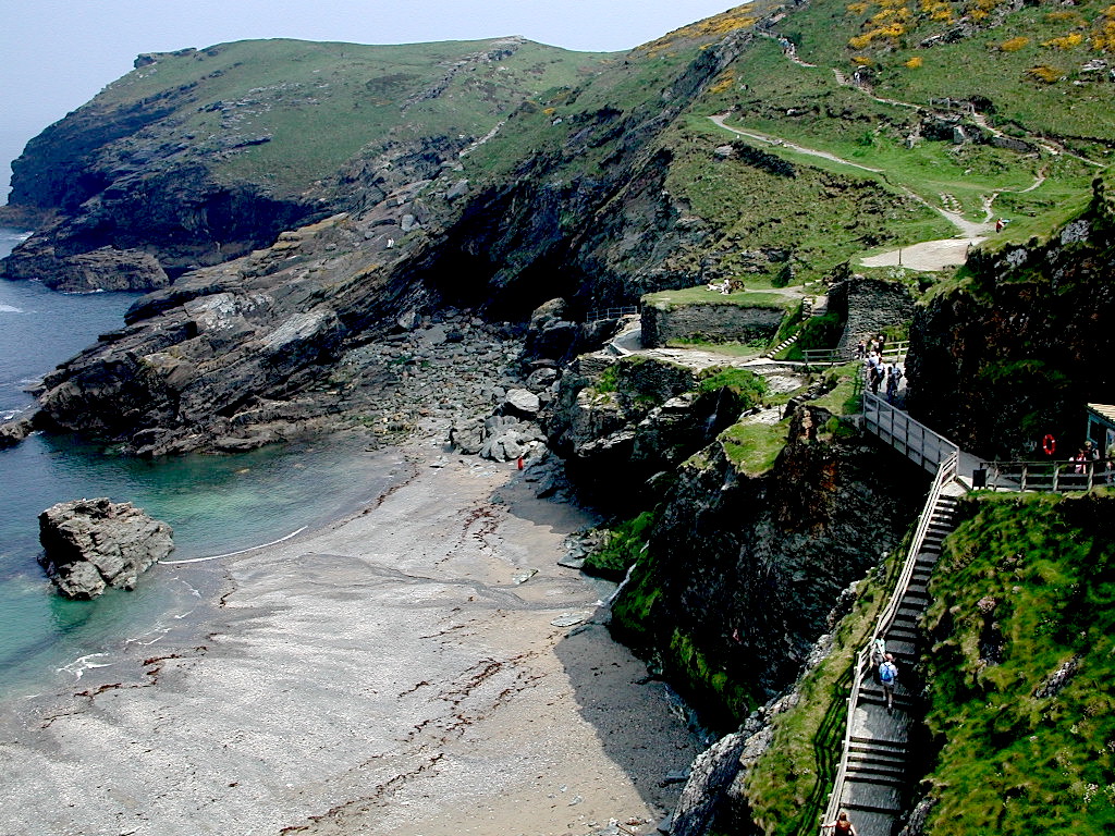
The forecast for the next day was for bright, sunny skies until the afternoon, so we decided to take advantage of the day by visiting Tintagel Castle in Cornwall. It was a long, three-hour drive, however we decided to make the all-day trip because I had wanted to visit Tintagel for many years, and Parthene was interested in seeing the Cornish coast. The first part of the drive was mundane as we made our way south down the M5, however once we got off the M5 and headed west towards the coast, the landscape changed to the more familiar farmlands and fields. This was eventually replaced by the wild and rugged landscape of the Cornish coast as we approached our destination.
Like Cheddar, the town of Tintagel, although pretty, is heavily geared towards tourism, the streets being lined with an array of tourist shops and accommodations, some quaint and some quite tacky. Just as parts of Scotland are overrun with Loch Ness monster souvenirs, Tintagel boasts a wide array of shops hawking cheap Arthurian gifts, Tintagel having been long associated with King Arthur and his knights of the round table. We found space in a car park off the high street and headed towards the castle with a picnic lunch secured in our backpack. It’s about a 15 minute walk to the castle, and although some of it is quite steep, the effort to reach the castle is more than rewarded by the beautiful scenery as you approach the coast. That’s the thing about Tintagel; it’s not the castle that’s the main attraction, but rather the setting, the Cornish coast. The castle, though spectacularly sited, is a typical 12th century Norman construction featuring only slight remains. Much more interesting are the remains of earlier huts and other buildings, low walls, some down to their foundations, that populate the site. The origins of some of these buildings are unknown and historians speculate that they may date to the Dark Ages around 600 AD.
The weather was beautiful for our visit. Although the day before most of the Cornish coast had been covered with clouds and mist, on this day we enjoyed sunny blue skies with temperatures approaching 70 degrees. There are two main hills on which the castle ruins rest, both reached via steep stairs that are not for the faint of heart. We decided to start with the main hill, and, once we maneuvered past a group of over-stimulated French high school students, we headed for the top of the hill above the castle ruins to get a better look at the coast and to find a picnic spot. We eventually located a nice set of rocks close to the summit of the hill overlooking the aforementioned ruined buildings. Although lower parts of the castle typically see many visitors, fewer bother to venture this far, and we enjoyed our picnic lunch of wine, cheese and bread in relative solitude.
Afterwards we decided to walk some of the coastal path nearby in order to take in the beautiful scenery. Here beautiful green hills suddenly end in steep, jagged cliffs that tumble down to the ocean where they are met by clear blue waters and crashing waves. Again, it becomes apparent very quickly to the visitor that the castle at Tintagel is only a secondary attraction. After lingering a bit longer on the main hill, we decided to hike our way up the even steeper stairs of the second hill, which contains the ruins of a castle hall and curtain wall. We were accompanied on much of this journey by a group of four friendly visitors from Scotland who, having been to Tintagel previously, were able to point out certain historical points of interest. Once we explored the castle ruins on the second hill, we exited the site and headed even further up the hill to the medieval church which is found a little further along the coast. By this time the day had grown hot and we were glad to escape into the cool interior of the church for a bit of a rest, before heading back to town via a small paved lane. We stopped for refreshments at a local shop before returning to the car for the long ride home. Having been dissatisfied with the uninteresting scenery along the M5 on the way down, we decided instead to return via the coastal road to the north, going through the fishing village of Bude. Although this route took about half an hour longer, it was worth the effort as we were able to enjoy different views of Devon and Cornwall. We got back to Tor Farm at about 6:30, feeling very fortunate to have spent such a wonderful day at one of Britain’s premier beauty spots. Our day in Tintagel was definitely one of the highlights of the trip.
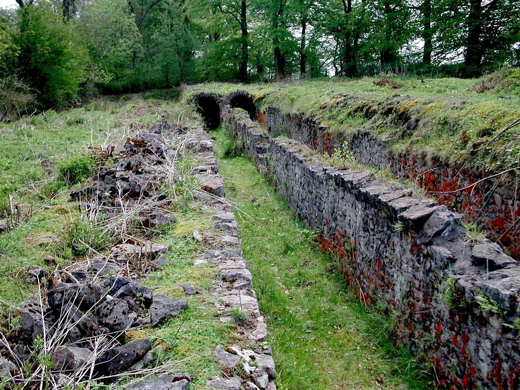
Our final two days were spent in the Mendips, exploring the sites and villages that would have been familiar to my Hares ancestors. The first morning, after mentioning that were interested in exploring the area’s lead mining ruins (if any), our host produced a walking guidebook and pointed out two walks that would afford us the opportunity to visit the region’s best lead works ruins. After breakfast we headed for the first of these walks near the village of Charterhouse only a couple of miles from Cheddar. With guidebook and camera in hand, we soon found a parking spot next to the public footpath where we chatted with a friendly local couple before heading down the path. They advised us of where to find the ruins we were looking for, and also told us that they had seen a couple of adders (snakes) on their walk, this being one of the first sunny days of the season. We thanked them and then started down the path.Although there were a variety of minerals mined in the Mendip Hills in the 18th and 19th centuries, the two principal minerals mined in Shipham were lead and "calamine," or zinc. In Shipham alone it was said that at the beginning of the 19th century there were as many as 100 mines in the parish, many of those in the little village itself. It is claimed that "houses" were often constructed quickly around and even on top of newly dug mines. The 1841 census of Shipham reveals that my own direct ancestors were lead miners, (Israel Hares and family), while other members of the family mined calamine. Over the decades the mining of lead in and around Shipham has left an indelible and peculiar mark on the landscape, some of which is still visible to this day. It is claimed by more than one publication, that Shipham in the late 18th and early 19th centuries was a lawless place of depravity, and that even law enforcement officials hesitated to enter the village. While there is little doubt that there is a great deal of truth in such observations, it is also likely that class prejudice played a significant role in these observations. It has even been suggested that some of the lawlessness of Shipham may be attributable to varying degree of lead poisoning suffered by its inhabitants.
The dozens of small mines and the piles of spoil they have produced over the years have transformed large sections of the landscape into tangles of bumpy hills and mounds, much of which are now grass covered, the so-called "gruffy ground" famous throughout the region. The spoils of lead mining have rendered the gruffy ground as well as other former mining land now developed unsuitable for the grazing of livestock. In addition, over the years there have been several incidents of residents being warned not to consume vegetables grow in soil on or near former mine works, although today these dangers have been largely dismissed.
As we began our Charterhouse hike, we were immediately struck by the aforementioned gruffy ground all around us. Lead mining here can be traced to Roman times, and in fact the low walls (grassy mounds) of a Roman fort can been seen from the public footpath. The lead works ruins here include piles of buddles (waste), smelting furnaces, flues used in the production of lead. I decided to climb over the low fence around the furnaces and flues to get a closer look, but retreated upon encountering one of the aforementioned adders, who was just as shocked to see me as I was to see him. Being satisfied with our expedition we decided to return to the car. Along the way we noticed many small snails on the ground with their pretty shells dotting both sides of the footpath, an interesting and beautiful sidebar to our hike.We decided next to visit the ancient medieval town of Axbridge, near Shipham. Axbridge was once a thriving center of activity in this part of the Mendips, but today flight from the town has transformed this once busy community into a quiet village. Axbridge features a lovely parish church set up high on a hill overlooking the town, and two beautifully preserved medieval buildings, including the so-called “King John’s Hunting Lodge,” which today houses the town’s history society and museum. We had lunch at a local pub, but saw little else of interest, so we departed. Having most of the afternoon left, we decided to head for the nearby cathedral city of Wells in search of a bookshop that might offer local titles on the history of the Mendips. Although we were unsuccessful in finding such a publication, it was enjoyable to revisit the city, explore the streets and view the magnificent exterior of the cathedral. On the way back to the car we bought a Cornish pasty at a local bakery, something we should have done the previous day in Tintagel. Nevertheless, the pasty was delicious and made for a fine dinner later that evening.
The next day we determined to undertake another hike in search of lead works, this time along the Priddy Mineries Reserve walk, an odd but beautiful combination of mine ruins and nature park, made possible primarily due to the lack of livestock grazing on the tainted land. Here we found ruins similar to the previous day, with the addition of man-made ponds that were used to scour the lead to remove impurities. We again met a friendly local couple (a mother and daughter) and their two dogs who were very happy to be out on the trail. The smaller dog, a Jack Russell terrier, liked the way I scratched him behind the ears, and was therefore my friend for much of the walk.
Afterwards we returned to the town of Cheddar with the thought of possibly visiting some of the caves, however we felt that the cost of the tickets was a bit too steep, considering we had only an afternoon remaining before our trip ended. We had good luck, however in locating two local history books, one of which featured specifically the industrial ruins of Somerset. We then decided to return to the Miner’s Arms in Shipham for our final pub lunch in Britain. Afterwards we returned to Tor Farm to relax and spend a final, restful night before facing the difficult journey home the next day.
Our time in Shipham was an absolute triumph, as we were able to accomplish all of our genealogy goals and then some. We managed to explore the village of my ancestors and get a feel for the countryside. We explored and photographed the church of St. Leonard’s where the Hares family worshiped for so many years. We hiked back into the countryside to locate ruins of the region’s lead mining industry, and we were able to locate books on the history the area. Finding the pub owned by the Hares family was an unexpected and pleasant bonus. This, following on the heels of our success in Brynmawr, made the second week of our trip both enjoyable and personally satisfying. We could have hardly hoped for better.
Jeffrey L. Thomas
May 2006
Home | Main Menu | Castle Index | Historical Essays | Recommended Castles | What's New | Links
Copyright © 2024 by Jeffrey L. Thomas